%20--%3e%3csvg%20version='1.1'%20id='レイヤー_1'%20xmlns='http://www.w3.org/2000/svg'%20xmlns:xlink='http://www.w3.org/1999/xlink'%20x='0px'%20y='0px'%20viewBox='0%200%2077.4%2077.4'%20style='enable-background:new%200%200%2077.4%2077.4;'%20xml:space='preserve'%3e%3cstyle%20type='text/css'%3e%20.st0{fill:%23D1181B;}%20.st1{fill:%23FFFFFF;}%20%3c/style%3e%3ctitle%3elogo_b%3c/title%3e%3cdesc%3eCreated%20with%20Sketch.%3c/desc%3e%3cpath%20id='Fill-34'%20class='st0'%20d='M26.7,56.1c-2,2-5.2,2-7.2,0c-2-2-2-5.2,0-7.2c2-2,5.2-2,7.2,0C28.6,50.9,28.6,54.1,26.7,56.1'/%3e%3cpath%20id='Fill-35'%20class='st1'%20d='M54.8,30.3H22.9l5.8-10.1H49L54.8,30.3z%20M64.4,20.1c-1.1-1.6-2.4-3-3.8-4.4H16.8%20c-1.4,1.3-2.7,2.8-3.8,4.4h10.4L8,46.8c0.5,2,1.2,3.9,2.1,5.7l10.3-17.9c0.1,0.1,0.3,0.2,0.5,0.2h36.4l10,17.4%20c0.9-1.8,1.5-3.8,2-5.8L54.3,20.1H64.4z'/%3e%3cpath%20id='Fill-36'%20class='st1'%20d='M38.7,7C21.2,7,7,21.2,7,38.7s14.2,31.7,31.7,31.7s31.7-14.2,31.7-31.7S56.2,7,38.7,7%20M38.7,77.4%20C17.4,77.4,0,60.1,0,38.7S17.4,0,38.7,0s38.7,17.4,38.7,38.7S60.1,77.4,38.7,77.4'/%3e%3c/svg%3e)
Yoshikawa : Randonnée sur le mont Myoken
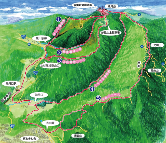
【Station Myokenguchi - Sommet du Mont Myoken】
Distance approximative du parcours et temps requis
① Le sentier Odougoe: 4,2 km / 95 minutes
② Le sentier Shintakimichi: 3,6 km / 80 minutes
③ Le sentier Uesugione: 4,3 km / 100 minutes
④ Le sentier Hatsutanikeikoku: 5,9 km / 120 minutes
⑤ Le sentier Tendaisan: 8,0 km / 190 minutes
Éditeur: Nose Electric Railway Co., Ltd.
Date de publication: janvier 2024
Si vous descendez du train à la gare de Myoken-Guchi sur le Nose Electric Railway (ligne Myoken), trois sentiers mènent au mont Myoken depuis la direction du Myoken Cable Lift : Le sentier Odougoe, le sentier Shintakimichi et le sentier Uesugione.
Les anciens chemins d'accès au sanctuaire de Myoken sont devenus des sentiers de randonnée, et vous pouvez y apprécier des touches élégantes qui ajoutent à la beauté de la nature, comme les portes des sanctuaires torii et les vestiges d'un four à charbon de bois.
Il y a au total cinq itinéraires si l'on ajoute le sentier Hatsutani et le sentier Tendaizan.
Le sentier Tendaizan est très varié puisqu'il passe par l'étang Dragonfly et le mont Aogai.
Vous pourrez admirer les buissons d'Edgeworthia, les fleurs et les oiseaux. Un sentier facile qui fait le tour de l'étang Dragonfly est également devenu populaire ces dernières années.
Pour plus de détails, veuillez vous adresser au centre d'information touristique situé en face de la gare de Myoken-Guchi.
Des cartes de randonnées sont également disponibles.