%20--%3e%3csvg%20version='1.1'%20id='レイヤー_1'%20xmlns='http://www.w3.org/2000/svg'%20xmlns:xlink='http://www.w3.org/1999/xlink'%20x='0px'%20y='0px'%20viewBox='0%200%2077.4%2077.4'%20style='enable-background:new%200%200%2077.4%2077.4;'%20xml:space='preserve'%3e%3cstyle%20type='text/css'%3e%20.st0{fill:%23D1181B;}%20.st1{fill:%23FFFFFF;}%20%3c/style%3e%3ctitle%3elogo_b%3c/title%3e%3cdesc%3eCreated%20with%20Sketch.%3c/desc%3e%3cpath%20id='Fill-34'%20class='st0'%20d='M26.7,56.1c-2,2-5.2,2-7.2,0c-2-2-2-5.2,0-7.2c2-2,5.2-2,7.2,0C28.6,50.9,28.6,54.1,26.7,56.1'/%3e%3cpath%20id='Fill-35'%20class='st1'%20d='M54.8,30.3H22.9l5.8-10.1H49L54.8,30.3z%20M64.4,20.1c-1.1-1.6-2.4-3-3.8-4.4H16.8%20c-1.4,1.3-2.7,2.8-3.8,4.4h10.4L8,46.8c0.5,2,1.2,3.9,2.1,5.7l10.3-17.9c0.1,0.1,0.3,0.2,0.5,0.2h36.4l10,17.4%20c0.9-1.8,1.5-3.8,2-5.8L54.3,20.1H64.4z'/%3e%3cpath%20id='Fill-36'%20class='st1'%20d='M38.7,7C21.2,7,7,21.2,7,38.7s14.2,31.7,31.7,31.7s31.7-14.2,31.7-31.7S56.2,7,38.7,7%20M38.7,77.4%20C17.4,77.4,0,60.1,0,38.7S17.4,0,38.7,0s38.7,17.4,38.7,38.7S60.1,77.4,38.7,77.4'/%3e%3c/svg%3e)
Mount Myojin Hiking Course — Panoramic Views and Six World Heritage Sites
Hiking Mount Myojin
Mount Myojin rises 273.6 meters above sea level, and its hiking course is approximately 2 km long.The varied route offers a relaxing way to enjoy the mountain’s natural surroundings, including mountain azaleas that bloom in spring.
 A large torii gate marks the starting point for the hike up Mount Myojin.
The route from the torii gate at the foot of the mountain to Mizu-jinja Shrine at the summit is known as Myojinsan Sando, the traditional approach to the summit shrine.
Most of the route is paved and gently uphill.
With an elevation gain of approximately 160 meters, it takes around 40 minutes to reach the summit.
The route is relatively easy to walk even for those who are not confident hikers, making it a pleasant course to enjoy while chatting with family or friends.
Mizu-jinja Shrine

Rituals have been held on Mount Myojin since ancient times, and the shrine has long been dedicated to a deity of water, an essential resource for agriculture.
360-Degree Panoramic Views from Mount Myojin
Three observation decks at the summit offer sweeping 360-degree panoramic views.Although Mount Myojin is not particularly high, it is said that ten of Japan’s former provinces could once be seen from here. Today, visitors can look out across the Nara Basin and the Ikoma and Kongo mountain ranges.
The Osaka Plain stretches out in the distance, offering an expansive view across the surrounding region.
Historic sites and buildings can also be seen, along with Abeno Harukas and, on especially clear days, the Akashi Kaikyo Bridge.
The summit provides a clear view of the surrounding terrain, rivers, and differences in elevation, making it easy to imagine the history that unfolded across this landscape.
(The “Mount Myojin 360-Degree VR Video” introduces the major historic and cultural sites visible from the summit through on-screen text and narration. You can click and drag the screen to look around and take your time exploring the scenery from Mount Myojin.)
Looking across a landscape shaped by the Kofun, Asuka–Nara, and Heian periods can feel almost like viewing a historical picture scroll, inviting you to imagine what these surroundings may have looked like centuries ago.
(“Time Travel from Mount Myojin: A Journey Through World Heritage and History” is a video that lets you enjoy the historic landscape visible from Mount Myojin while imagining how the area may have looked in the past.)
A Romantic Spot for a Proposal
Mount Myojin has also been designated as a “Lover’s Sanctuary.”Recognized as a romantic place for proposals, the summit observation deck features the “Bell of Eternity,” where couples can ring the bell together and pledge their lasting love.
The sunset also makes a memorable backdrop for photos together.
Lover’s Sanctuary “Bell of Eternity”

At one of Oji Town’s most scenic viewpoints, why not ring the bell together with someone special?
Six World Heritage Sites Visible from Mount Myojin
Mount Myojin offers another remarkable feature that makes its summit especially distinctive.From here, you can look out toward six UNESCO World Heritage properties.
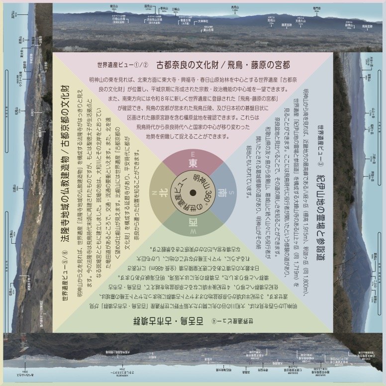
① “Historic Monuments of Ancient Nara”
② “Ancient Capitals of Asuka and Fujiwara”
③ “Sacred Sites and Pilgrimage Routes in the Kii Mountain Range”
④ “Mozu-Furuichi Kofun Group: Mounded Tombs of Ancient Japan”
⑤ “Buddhist Monuments in the Horyu-ji Area”
⑥ “Historic Monuments of Ancient Kyoto (Kyoto, Uji and Otsu Cities)” (including Enryaku-ji on Mt. Hiei)
The view includes the newly inscribed “Ancient Capitals of Asuka and Fujiwara,” added to the UNESCO World Heritage List in July 2026. Looking toward Osaka, you can also see the Mozu-Furuichi Kofun Group area and Abeno Harukas, while on especially clear days the view can extend as far as the Akashi Kaikyo Bridge.
These landscapes encompass places of major historical and cultural importance in Japan.
Consider adding Mount Myojin to your sightseeing route and enjoy a panoramic view across centuries of Japanese history.
 The Mount Myojin Live Camera provides regularly updated views from a camera installed at the summit.
The image is updated every 10 minutes.
Mount Myojin Information
【Address】
・Oji, Nara
【Phone Number】
・0745-33-6668 (Oji Town Tourism Association)
【Access】
・From the south exit of JR Oji Station, take a Nara Kotsu bus bound for Myojin 4-chome. Ride for approximately 20 minutes to the final stop, then walk approximately 40 minutes to the summit.
Return to Oji Town